
GMDSS Modernization
2022-12-16 18:29
Introduction
The Global Maritime Distress and Safety System (GMDSS) provides an integrated solution for distress, emergency, safety and conventional communications, and is the main platform for ship-shore, ship-to-ship information interaction. In order to coordinate development with the E-Navigation strategy, IMO proposed a GMDSS review and modernization plan in April 2008.
With the rapid development of the shipping market, the development of ships also tends to be large-scale, intelligent and specialized, and the capabilities of existing communication equipment on board ships can hardly keep up with navigation safety technology. Technological advances in electronics, radio communications, and information technology have led to new revolutionary proposals to upgrade the equipment and systems used on sea-going vessels. The standards and scope of the equipment on board are playing key role in ensuring these vessels’ safety that strictly monitored by the International Maritime Organization (IMO) and its subsidiary bodies.
The launch of GMDSS modernization is mainly due to the fact that the existing GMDSS system has been launched for too long, and the technology used in many equipment is relatively old and outdated. The GMDSS, which was fully implemented on 1 February 1999, was expected to represent, at the time, a revolution in maritime communications. Its main purpose is to alert and warn coast centers and surrounding ships in cases of distress, urgency, and safety. It can also be used for routine (commercial) communications. According to the GMDSS requirements, the amount of communication equipment on ships, depends on the area of navigation (A1–A4) and includes terrestrial and satellite devices. GMDSS provides plans in case of distress, emergencies, safety and standard communication.
It is the main communication platform used for ship-shore and ship-ship information sharing. The first phase of the GMDSS modernization involved a "High-Level Review", which analyzed the basic elements of GMDSS. In the second phase of 2013- 2016, a “Detailed Review” of GMDSS was conducted. The other phase was completed in 2017 and involved preparations for the “GMDSS Modernization Plan”.
In this article, considering the finalization of the requirements related to the modernization of GMDSS, we are going to state the generalities of this matter.
GMDSS Modernization
SOLAS 2024 amendments, that driven by MSC 105, and which will take into effect on 1st Jan. 2024, contains the changes that have been adopted for the 2024 update of SOLAS and its associated Codes.
The requirements to the Global Maritime Distress and Safety System (GMDSS) have been modernized to contain more generic requirements, independent of specific service providers, and to remove carriage requirements for obsolete systems. Furthermore, the requirements for communication equipment have been moved from SOLAS Chapter III on life-saving appliances to Chapter IV on radio communications. The definitions of the sea areas A1 to A4 have been amended to reflect that the geographical area of coverage may vary between various satellite service providers.
Since the IMO adopted the worldwide system for communication of emergency information in 1988, Inmarsat has been the only approved provider of satellite communication services for the GMDSS. In 2018, the IMO also recognized Iridium as a provider of such services, and the 2020 update of SOLAS replaced provider-specific terms with the more generic “recognized mobile satellite service”.
Consequential amendments have been made to the 1994 and 2000 High-Speed Craft (HSC) Codes, the Special Purpose Ships (SPS) Code and the Mobile Offshore Drilling Units (MODU) Code.
The amendments will enter into force on 1 January 2024. Existing SOLAS certificates do not have to be reissued before they expire as a consequence of the reorganization of SOLAS Chapters III and IV.
What’s new?
1- Criteria for establishing GMDSS sea areas
Governments should use the following criteria when establishing sea areas as defined in SOLAS regulation IV/2. Each Government should submit to the Organization information on the sea area or sea areas (A1, A2, A3 and/or A4) designated, radio communication services it has established for the GMDSS, and when there are changes to the sea area or areas it has so defined.
Governments, individually or in cooperation with other Governments, desiring to provide DSC coast stations (HF, MF or VHF) for use in the GMDSS should notify the Organization so it can maintain in the GMDSS Master Plan details of coast stations providing DSC distress watch. In addition, Report ITU-R M.2027 provides engineering guidance to upgrade shore-based facilities to operate the GMDSS in sea areas A1, A2, A3 and A4.
SEA AREA A1
The communication range of stations operating in the maritime mobile VHF band is likely to be limited by propagation factors rather than lack of radiated power.
Sea area A1 is that sea area which is within a circle of radius A nautical mile over which the radio propagation path lies substantially over water. The radius A is equal to the transmission distance between a ship's VHF antenna at a height of 4 m above sea level and the antenna of the VHF coast station which lies at the center of the circle.
The following formula should be used to calculate the range A in nautical miles:
A = 2.5 (√H (in meter) + √h (in meter))
- H is the height above sea level of the VHF coast station receiving antenna and
- h is the height above sea level of the ship's transmitting antenna which is assumed to be 4 m.
The formula given above applies to line-of-sight cases but is not considered adequate for cases where both antennae are at a low level. The VHF range in sea area A1 should be verified by field strength measurements.
SEA AREA A2
Consideration of the reception of radio signals in the 2 MHz band indicates that the range is likely to be limited by propagation conditions and atmospheric noise, which are affected by variations in geographical position and time of day, as well as radiated power.
The theoretical distance to be expected from ground-wave propagation can be determined by reference to the "Ground-wave propagation curves for frequencies between 10 kHz and 30 MHz" in the most recent version of Recommendation ITU-R P.368, to be used above seawater and adjusted as necessary to take account of the actual radiated field strength from the transmitting antenna and the minimum field strength necessary for the proper operation of a receiver conforming with the latest performance standard adopted by the Organization.
The determination of the minimum signal level required for satisfactory radio reception in the absence of other unwanted signals necessitates taking account of the noise with which the wanted signal must compete. The latest Recommendation ITU-R P.372 gives the world distribution of values of noise level and of other noise parameters and shows the method of using these in the evaluation of the probable performance of a radio circuit.
In addition, the most recent version of Recommendation ITU-R M.1467 provides guidance to
Administrations for predicting sea area A2 by taking into account variations in the propagation conditions.
Sea area A2 is that sea area which is within a circle of radius B nautical miles over which the propagation path lies substantially over water and which is not part of any sea area A1, the center of the circle being the position of the coast station receiving antenna.
Determination of radius B
The radius B may be determined for each coast station by reference to the most recent versions of
Recommendations ITU-R P.368 and ITU-R P.372 for the performance of a single sideband (J3E) system under the following conditions:
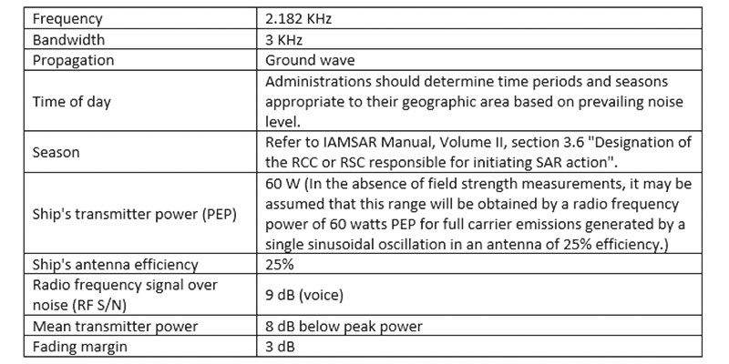
The range of sea area A2 should be verified by field strength measurements. (IMO Res. 801 (19))
SEA AREA A3
Sea area A3 means an area, excluding sea areas A1 and A2, within the coverage of a recognized mobile satellite service supported by the ship earth station carried on board in which continuous alerting is available.
SEA AREA A4
Sea area A4 means an area outside of sea areas A1, A2 and A3.
2- CRITERIA FOR USE WHEN PROVIDING A NAVTEX SERVICE
There are two basic areas which must be defined when establishing a NAVTEX service. They are:
- Coverage area: An area defined by an arc of a circle having a radius from the transmitter calculated according to the method and criteria given in this part.
- Service area: A unique and precisely defined sea area, wholly contained within the coverage area, for which MSI is provided from a particular NAVTEX transmitter. It is normally defined by a line which takes full account of local propagation conditions and the character and volume of information and maritime traffic patterns in the region.
Governments desiring to provide a NAVTEX service should use the following criteria for calculating the coverage area of the NAVTEX transmitter they intend to install, in order to:
- Determine the most appropriate location for NAVTEX stations having regard to existing or planned stations;
- Avoid interference with existing or planned NAVTEX stations; and
- Establish a service area for promulgation to seafarers.
The ground-wave coverage may be determined for each coast station by reference to the most recent versions of Recommendations ITU-R P.368 and ITU-R P.372 for the performance of a system under the following conditions:
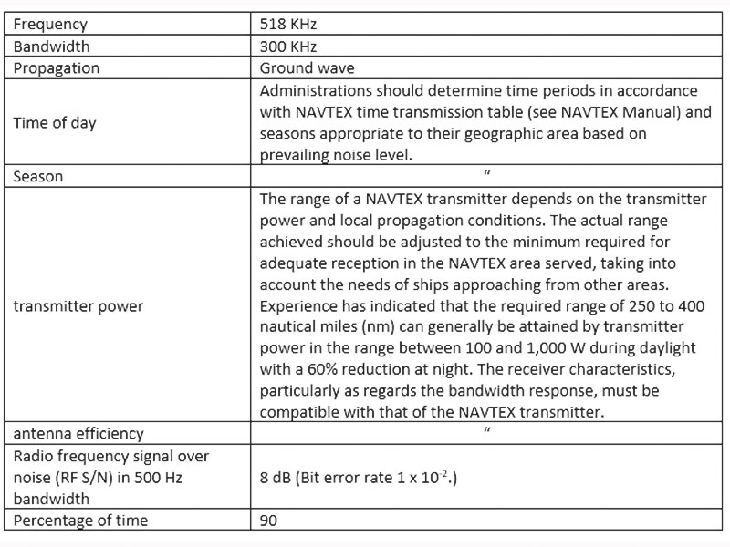
Full coverage of NAVTEX service area should be verified by field strength measurements. In addition, the most recent version of Recommendation ITU-R M.1467 provides guidance to Administrations for predicting NAVTEX coverage areas by taking into account variations in the propagation conditions.
3- New Performance Standards
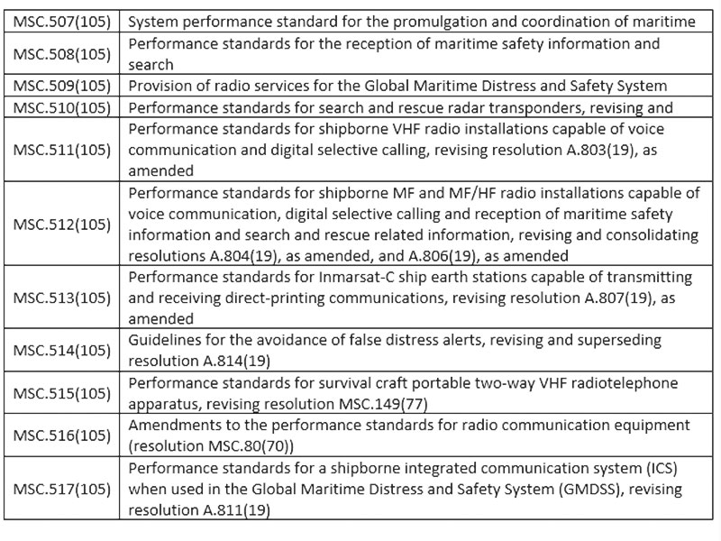
Various guidelines and Performance standards, were approved at MSC 105 for the application from 1 Jan 2024, as follows:

Admin
Related Articles

A general guidance on the radio survey - Part I
2022-04-13 13:04
Routine test of radio equipment
2022-11-30 11:11

Emergency Position Indicating Radio Beacon (EPIRB)
2023-12-30 14:12